War in Ukraine
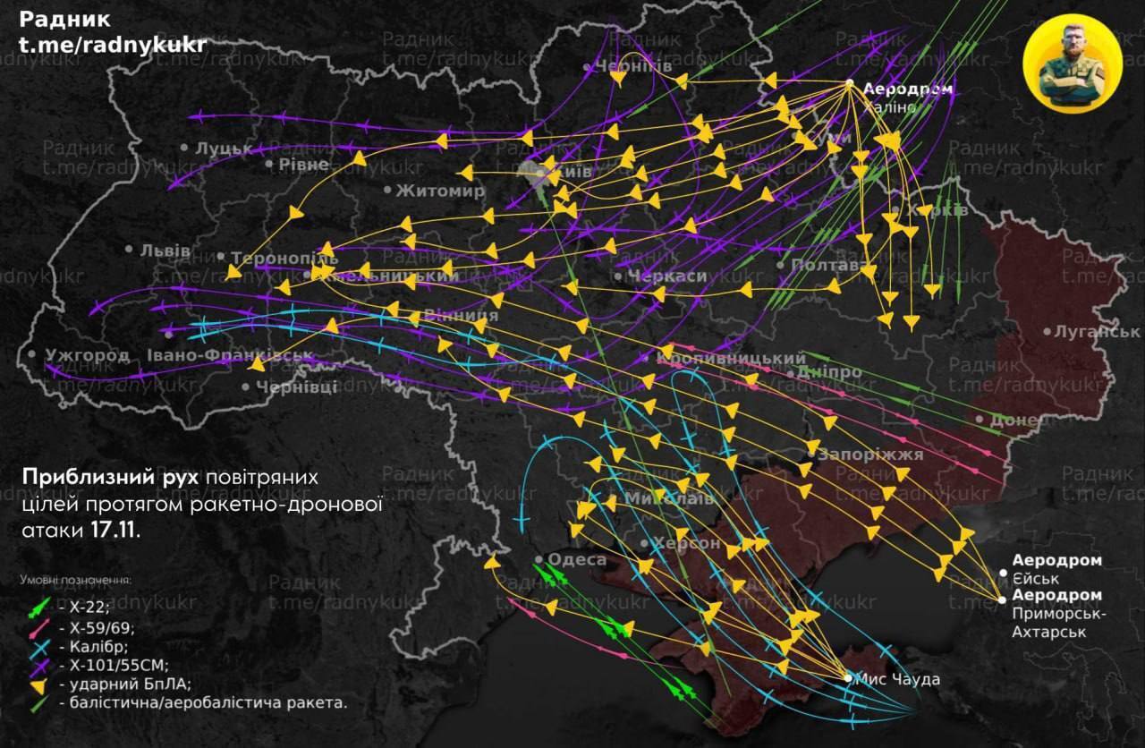
Map of missiles and drones movement during the massive attack on Ukraine is shown online
On the morning of November 17, Russian terrorists launched another massive attack on Ukraine. During the attack, the enemy used cruise, ballistic, and aerial ballistic missiles, as well as kamikaze attack drones.
Russian missiles and drones entered Ukraine from the north, east, and south. A map of the movement of missiles and drones during the massive attack was published on Telegram.
In the north, the Russians launched kamikaze drones from the Khalino airfield in the Kursk region, and in the southeast, from airfields in Yeysk and Primorsko-Akhtarsk.
Cruise missiles were fired at Ukraine from ships in the Black Sea, as well as from Tu-95MS strategic bombers. In addition, Putin's terrorists launched a number of ballistic and aerial ballistic missiles.
According to the Air Force of the Armed Forces of Ukraine, a total of 210 enemy air targets – 120 missiles and 90 UAVs – were detected and escorted by radio engineering troops. The enemy attacked the energy sector facilities of Ukraine.
The map shows that on the morning of November 17, Russian missiles or drones flew over almost every corner of the country.
As a reminder, on the night of November 17, Russia launched a massive combined attack on all regions of Ukraine. The enemy launched about 120 missiles and 90 drones at Ukrainian cities and villages. The air defense forces destroyed more than 140 enemy air attack vehicles, the invaders targeted primarily the energy sector, and there were casualties.
Earlier it was reported that during a massive missile and drone attack by Russian troops on the night of November 17, F-16 pilots shot down about 10 air targets. Currently, the consequences of the enemy terror are being eliminated in Rivne, Lviv, Dnipro, Volyn, and Odesa regions.
Only verified information is available on our Telegram channel OBOZ.UA and Viber. Do not fall for fakes!


