News

The best destinations in the Carpathians


The world is big and beautiful, and it is worth exploring. However, have you seen enough in Ukraine? After all, even foreign tourists are often attracted to our flora and fauna like honey. So maybe we should start with our own fantastic landscapes?
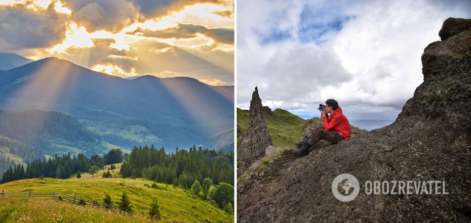
Today, those who have dreamed of seeing the Alps with their own eyes will be happy. In fact, our Carpathians are no worse. And especially the Marmarosy: a massif that is so popularly compared to its European "brothers". And they are just a stone's throw away. In addition, in the fall, nature will be "burning" with colorful shades of yellow, red and orange.

Maramureș
The majority of this mountain range in the Eastern Carpathians lies on the Romanian side. Ukraine is home to its northern and northwestern outskirts, including the Chyvchyny and Rakhiv Mountains. Due to the unusual landscape of the Carpathians, they are also called the Hutsul Alps, as the rocky hills seem to transport you to another dimension. Needless to say, the local landscapes are fabulously beautiful. In addition, these are the oldest Beskydy of the Carpathians.
According to scientists, the geological structure of the Maramureș is unique. They serve not only as a natural border between Ukraine and Romania, but also as a border between the Southern and Eastern Carpathians. Here you can see many rare plants, as well as glacial karas (bowl-shaped depressions formed by small glaciers).
The best time to visit this massif is in early and mid-autumn. During this period, the nights are slightly cooler and it may even snow. Some tourists will recall making their way up the steeps through snowdrifts, so the path is likely to be difficult. However, there is something to strive for! After all, amazing views await you at the top.

Pip Ivan (Maramureș)
This is the highest mountain of the massif, 1936 meters high. The shape of the peak resembles a pyramid, and the slopes are steep and steep. But don't get it confused, there are two rocks of this name in the Carpathians: the other (2028 meters) is located at the end of the main ridge of the Chornohora massif. Tourists are even offered a route from "Popa to Popa", but it is suitable only for very experienced travelers, because it lasts a whole week. And that's if the weather is good.

How to get a permit
You may already know that the Maramureș Mountains trail runs along the state border between Ukraine and Romania. To stay in this area, you need to get a special temporary permit.
There will be no higher math: 5-7 days before the start of the trip, you should write a letter to the commander of the Mukachevo border guard detachment. Specify the participants of the trip, passport data, tell about your destination and the date until which you will be there. A sample text is available online. Send the document itself by fax or mail.
A few days before the expedition, it is better to call back to the border post in the village of Dilove and find out if you have received consent from the local authorities. If so, it will be at the Dilove border post that you will be given a copy of the application letter after checking your documents and having a copy of the application. According to the rules, you must have a GPS navigator, a map, and a detailed route. You will also have to report daily on the location and condition of the group by sending SMS messages.

How to get to Maramureș
If you need to go to Mount Pip Ivan, the road can start from Rakhiv, Kostylivka, or Dilove. There are buses from Ivano-Frankivsk and Uzhhorod to these settlements.
If you choose Dilove, the path will start in the center of the village near the bridge over the Tysa River. After you cross it, you should go around the church on the right side. After 1 kilometer you will find yourself at the checkpoint of Dilove forestry. Then, walking along the White Stream, you will reach the peaks. The length of the route is about 22 kilometers.
The first views will open up at the crossroads of the Shchevora, Berlebashko, Lysych and Pop Ivan Maramureș meadows. By the way, you can climb the Lysycha valley, which for most people is the pass before the main rush, not only on foot but also in off-road vehicles. However, the road to the very top of the mountain is a matter of your feet. The distance from the clearing to the top of the mountain is about 2.5 kilometers. And the route is not easy, because it is quite steep.

Mezhipotoki, Mika Mare and Stig peaks
Despite the fact that Pip Ivan is the most popular mountain in the Maramureș, some people choose to go the other way. For example, to climb the neighboring rock Mezhypotoky (1713 meters), the Stig hill (1650 meters) or Mika-Mare (1815 meters).The latter is also called Neneska or Neniska, which means "aunt" in Hutsul dialect.
Regardless of their height, the path will be difficult. But when you take the last step and stand on the highest mountain point, the fatigue disappears. Your heart flies out of your chest and you realize what you were going for. Here is freedom, here is air that cannot be breathed. Here are the landscapes that you want to remember and recall how beautiful our country is. Here you realize that it was worth it!
Earlier, OBOZREVATEL told you about the little-known routes of the Carpathians.
Only verified information is available on our Obozrevatel Telegram channel and Viber. Don't fall for fakes!
Other News


How to boil beets in 10 minutes: an elementary method that will suit everyone
You don't even have to turn on the stove

A new rival to Renault's inexpensive Tesla crossover was shown from the inside. Photo
Alpine A390 will be very powerful


The most fashionable manicure color for spring 2025: five periwinkle designs
Spring 2025 brings a new color favorite in the world of manicure

The most successful days of March for each zodiac sign: horoscope
On which days the stars will be most favorable in business