News


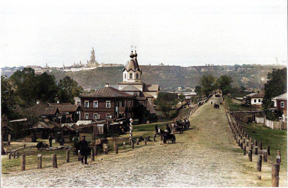
The neighborhood of Left bank. Source: Kyiv Historical Telegram channel


Old photographs evoke not only nostalgia but also a special awe of the past. Today, the Left Bank Massif is one of the most densely populated areas, but the area began to acquire its modern look only in the 1970s.
Previously, the historical area of Mykilska Slobidka was located on the territory of the Left Bank Massif. The network showed what the neighborhood looked like 130 years ago.
Nowadays, the Left Bank Massif is conditionally divided into two parts by Brovarskyi Avenue and the ground part of the Sviatoshynsko-Brovarskyi subway line.
However, the northern part of the neighborhood is still called Mykilska Slobidka by local residents.
In chronicles, this territory has been mentioned since the fifteenth century as "semi-princely land." In 1508, the land became the property of the Pustynno-Mykilskyi Monastery, which is where the name came from.
When the General Description of Left-Bank Ukraine was made in 1765-1769, Mykilske village was included in the list of settlements of the Hoholivska Hundred. As of 1781, there were 31 houses in the settlement, and according to the 1787 inventory, the population was only 128 people.
Since the seventeenth century, there have been churches on the territory of Mykilska Sloboda, the last of which, a wooden church on a stone foundation with a bell tower, was built in 1880. Under Soviet rule, the church was destroyed.
From the eighteenth century, Mykilska Slobidka became a workers' settlement, mainly for workers of the Arsenal plant.
According to the nineteenth century, there was an inn on the territory of the village where travelers rested before crossing to Kyiv.
In 1906, the Rusanivskyi Bridge was built from Mykilska Slobidka towards Kyiv, and in 1912 a special gasoline-powered tram from Kyiv started running to the village.
Later, the settlement was connected by tram to Darnytsia and the city of Brovary.
Mykilska Slobidka was formed by three "corners": Pozharyshche, Behind the Cemetery, and Dachnyi.
Since 1923, Mykilska Slobidka has been included in the city limits of Kyiv.
Subscribe to OBOZ.UA channels on Telegram and Viber to keep up with the latest events.
Other News


"I'm not trying to mock": former world champion spoke humiliatingly about Usyk
The Briton spoke about the success of our compatriot

How to get rid of mold and odor in the washing machine: an effective method
These products are always at hand


Healthy beetroot salad with eggs and cheese: tastier than "Shuba" and "Vinegret"
Preparing a dish without mayonnaise

Cherry McPie at home in seconds: it will be tastier than in a restaurant
It is worth trying to cook yourself