Life

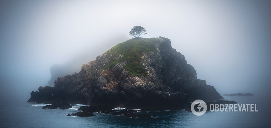
Sometimes these islands were described as lonely rocks shrouded in fog.


Despite the fact that the era of geographical discovery is considered to be long over, maps of different parts of the world are still being refined and improved. Among other things, scientists are looking for traces of landmasses that were once depicted on ancient maps and then disappeared.
The IFL Science publication told us about several such ghost islands. They could have gone underwater for various reasons or even never existed.
Brazil
This is one of the most famous ghost islands, believed to be located off the west coast of Ireland. It was described as a tiny, fog-covered rock in the Atlantic Ocean. It was first mapped in 1325, but further attempts to pinpoint its location proved futile. Therefore, a mystical theory arose that Brazil emerges only once every seven years and attracts sailors, but they pass through it on their ships as if through fog.
A more detailed description of the alleged island was left by Captain John Nisbet. In his notes, he recounted how he and his crew were stranded on Brazils and described it as a deserted castle where they met a ghost who told them about the island's ancient history over a lavish banquet.
Brasil was most actively sought in the 15th century, when several expeditions were sent to the island. The last one was led by John Cabot. But he sailed to North America without coming across the vision. Since 1865, the island has ceased to be marked on maps. Most likely, it never really existed.
Antilles
The island of seven cities was "found" in the Atlantic Ocean to the west of Portugal and Spain, about 200 miles from the Azores archipelago. The earliest mention of it dates back to the first century AD.
A map of Antilles made by the scientist Paolo Toscanelli in 1474 prompted Christopher Columbus to plan a stopover here when he was on his expedition to India. But he never found the island. As a result, Columbus named the archipelago off the coast of America the Antilles.
Since after 1492. sailors began to explore the North Atlantic more frequently, the island appeared less and less often on new maps, and its mysteries began to be associated with Central and North America. The last appearance of the island was recorded on the 1631 Hondius world map.
Bermuda
The tiny piece of land off the coast of Mexico was first mapped in 1539. According to estimates at the time, it was no more than 80 square kilometres in size and had red soil. During the 16th and 17th centuries, Bermuda was an integral part of maps of the region. But from the 18th century onwards, it appeared on them less and less and was last marked in the 1921 Geographical Atlas of the Mexican Republic.
Unexpectedly, the island was talked about in 2009. This happened after the 1997 discussion on international water areas in the Gulf of Mexico, during which the United States and Mexico planned to divide the Ojos de Dona international waters. It was in this region that Bermuda was allegedly located. If its existence had been confirmed, it would have allowed Mexico to expand its maritime border and given the country the right to the oil fields located there. However, the search led nowhere. In the end, the countries signed a treaty stating that Bermeja did not exist. But in 2009, the search resumed. And again unsuccessfully. Mexico lost the rights to 22.5 billion barrels of oil to America. Instead, a conspiracy theory emerged, according to which the US government allegedly destroyed the island on purpose. However, it is absolutely impossible to do this unnoticed.
Sable, or Sandy Island
This piece of land was put on his map in 1776 by Captain James Cook. He "spotted" it off the east coast of Australia. Over the next 200 years, Sublime regularly appeared on maps, and its exact coordinates were first established by the crew of a whaling ship in 1876.
Geographers were confident in the island's existence until the end of the 20th century. It could even be found on early versions of Google Maps. The final point in the debate about the existence of Sabla was put by radio amateurs who went on a special expedition in 2000 to look for it, but found nothing.
However, in 2012, Captain Fred Stein and marine geologist Maria Seton, who were in the area, decided to warn their team about possible obstacles in the water. This was indicated, in particular, by a mark on Google Maps that has not yet been removed. However, their ship passed through the alleged Sabl without any problems. After that, the island was declared "undiscovered" and removed from the online mapping service.
Earlier OBOZREVATEL told that the scientists have discovered deep under the surface of the Earth the probable bottom of the ancient ocean.
Subscribe to OBOZREVATEL's Telegram and Viber channels to keep up with the latest news.
Other News


They are back on their honeymoon: Meghan Markle tells how she made Prince Harry fall in love with her again after seven years of marriage
The spark has not yet faded between the spouses

"There is no such thing as overweight": Yevhen Klopotenko describes the ideal woman for him and explains why he doesn't pay attention to appearance
Personal traits of a partner are important for a restaurateur


Rock legend Neil Young has announced a free concert in Ukraine
Negotiations on the organization of the concert are underway

He promised a "fee" for destroyed tanks of the Armed Forces of Ukraine: Grigory Leps received a suspicion from the SSU in absentia
In 2023, the artist traveled to occupied Donetsk