News

The northernmost island on Earth turned out to be a dirty iceberg.


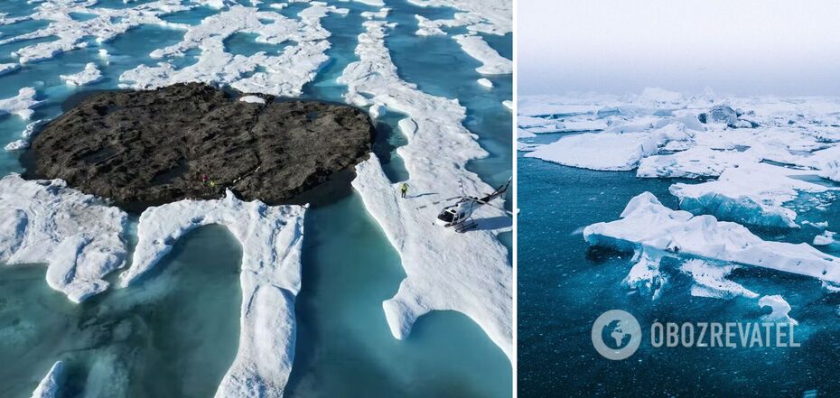
The island found in the Arctic near Greenland in 2021, which was considered the northernmost on planet Earth, turned out to be just a "dirty iceberg" but gave scientists a clue to the mystery of Arctic ghost islands that suddenly disappear.
The small island, measuring about 30 by 60 meters, was discovered in 2021 by an expedition involving researchers from Swiss, Danish, and Greenlandic institutions, The Conversation writes. At the time, they called it "Qeqertaq Avannarleq", which means "the northernmost island" in Greenlandic.
"(The island) was small and gravelly, and it was declared a contender for the title of the northernmost known land mass in the world," wrote Kevin Hamilton, a professor of atmospheric science at the University of Hawaii.
He noted that the island was not the first to be found in the region in recent decades, but the fate of previous finds had left scientists in a quandary, as they simply disappeared.
The first such ghost island was found in 1978, and then several more similar islands were discovered, which at some point simply disappeared. After studying the phenomenon, researchers suggested that the discoverers were not dealing with islands, but with rocky shores at the bottom of the sea that were pushed to the surface by sea ice.
However, when a group of Swiss and Danish surveyors traveled north to investigate the ghost islands, they found something else. In September 2022, they announced their findings: these elusive islands are actually large icebergs that have sunk to the seabed. Most likely, they floated from a glacier, where surveyors found other similarly dirty icebergs ready to set sail at any moment.
After the discovery, scientists will have to revise updated maps to clear them of what were thought to be newly discovered islands.
It should be noted that this is not the first time that scientists have had to change the maps of the Arctic. The most famous case occurred in 1931, when a joint expedition of German, Soviet, and American scientists and researchers explored the Arctic for five days aboard the Graf Zeppelin airship.
"Our first goal was an island called Albert Edward Land. But this was easier said than done, because Albert Edward Land had the disadvantage that it did not exist. It could be found on any map of the Arctic, but not in the Arctic itself," wrote the chronicler of the expedition, journalist Arthur Koestler.
Next, the scientists had to explore the Harmsworth Land, but it turned out to exist as well.
"Where it was supposed to be, there was nothing but the black polar sea and the reflection of the white Zeppelin. Only heaven knows whether the explorer who mapped these islands (I believe it was Peyer) was not a victim of a mirage, mistaking some icebergs for land," Koestler wrote.
The 1931 expedition also discovered six new islands and clarified the outlines of many others. Here is an archived video about that trip.
As OBOZREVATEL previously reported, scientists have said that the Antarctic Thwaites Glacier, also called the "Doomsday Glacier," is likely to collapse much earlier than expected. Its destruction may also threaten Ukraine.
Other News


The long-awaited VW crossover cheaper than Duster was shown in photos
The Tera is being prepared for the premiere

How to boil beets in 10 minutes: an elementary method that will suit everyone
You don't even have to turn on the stove


Delicious and healthy "Napoleon" made from phyllo dough: it takes a few minutes to prepare
The easiest way to make a popular dessert

The most fashionable manicure color for spring 2025: five periwinkle designs
Spring 2025 brings a new color favorite in the world of manicure